
மழை பொழிந்த நண்பகல் நேரம்
விசும்பு ஆடு பறவை வீழ் பதிப் படர,
நிறை இரும் பெளவம் குறைபட முகந்து கொண்டு
அகல் இரு வானத்து வீசு வளி கலாவலின்,
முரசு அதிர்ந்தன்ன இன் குரல் ஏற்றொடு,
நிரை செலல் நிவப்பின் கொண்மூ மயங்கி,
இன்னிசை முரசின் சுடர்ப் பூண் சேஎய்
ஒன்னார்க்கு ஏந்திய இலங்கு இலை எஃகின
மின் மயங்கு கருவிய கல் மிசைப் பொழிந்தென (குறிஞ்சிப்பாட்டு)
வானத்தில் பறக்கும் பறவைகள் தாங்கள் விரும்பும் கூடுகளுக்குச் செல்லுமாறு, நீர் நிறைந்த பெரிய கடல் குறையுமாறு, முகில் கூட்டங்கள் நீரை அள்ளிக் கொண்டு, மிக அகன்ற வானத்தில் வீசுகின்ற காற்றுடன் கலப்பதால், முரசு அதிர்ந்தாற்போன்ற இனிய குரலை உடைய இடியுடன் கூடி வரிசையாக மேலே சென்று கலங்கி, இனிய இசையை உடைய முரசினையும் ஒளியுடைய அணிகலன்களையும் உடைய முருகன், பகைவர்களைக் கொல்லும்பொருட்டு, கையில் கொண்ட விளங்கும் இலையையுடைய வேல் ஆயுதத்தைப் போன்று உள்ள மின்னலுடனும் இடியுடனும் கூடிய தொகுதியுடையதாக, மலை மீது பொழிந்தன. On the day of சூரசம்ஹாரம் its perhaps apt to bring a quote from குறிஞ்சிப்பாட்டு about thunderstorms.
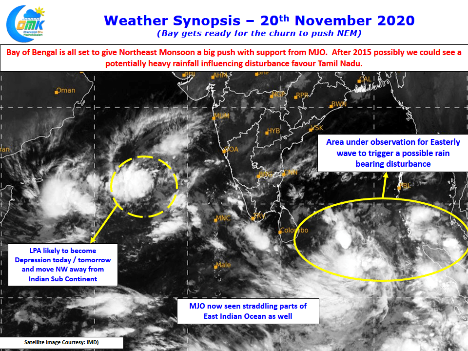
It has been a few years since we saw a proper rain bearing disturbance head towards Tamil Nadu. After maybe 2015 which saw multiple systems bring episode after episode of heavy rains we could possibly see the first disturbance that could potentially bring good widespread rains across the state.
Bay of Bengal is getting ready to push North East monsoon with the support of MJO over the next fortnight or so. The equatorial waters of South Bay a likely to churn a possible low pressure early next week or so by which court favorably move towards coastal Tamil Nadu.

In the meanwhile except for some isolated rains over South Tamil Nadu the rest of the state is likely to see dry weather conditions prevail as the low pressure over Arabian Sea moves further West making its influence gradually fade. In a way the current dry weather may be a a positive turn of events to allow soaked areas of South Tamil Nadu to dry a bit before the next rainfall episode.