
“A rose by any other name would smell as sweet” is a very popular quote from Romeo and Juliet by William Shakespeare. Hurricane, Typhoon, Cyclonic Storm are names used by various meteorological agencies across the globe. But all of them are Tropical Cyclones by nature. IMD uses “Deep Depression” as an intermediary stage between Tropical Depression and Tropical Storm. This in effect is a marginal cyclone. When the sustained wind speeds are 28 to 33 knots IMD classifies it as Deep Depression. When the sustained wind speeds increase to 34 knots it is classified as a Cyclonic Storm.
Currently the Deep Depression is to the East of Sri Lanka at roughly about 200 kms SE of Batticaloa. Over the past 12 hours or so it has been showing a more pronounced NW movement. This pronounced NW movement is in sync with ECMWF (both ensembles and deterministic) and the ML models. Earlier models like GFS expected the initial WNW movement to persist. This meant some of the initial track forecast including IMD opted to bring it closer to SE coast of Sri Lanka. With the NW movement now, there is increasing possibility of the Deep Depression now moving closer to the NE coast of Sri Lanka. Satellite images indicate the circulation may have reached its peak intensity. Any increase in intensity from now on could be marginal as wind shear impact starts taking effect.
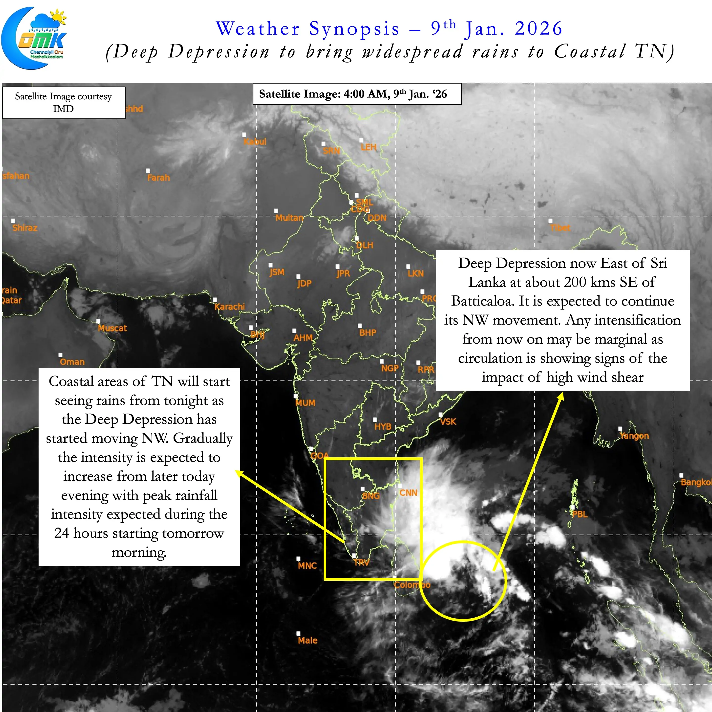
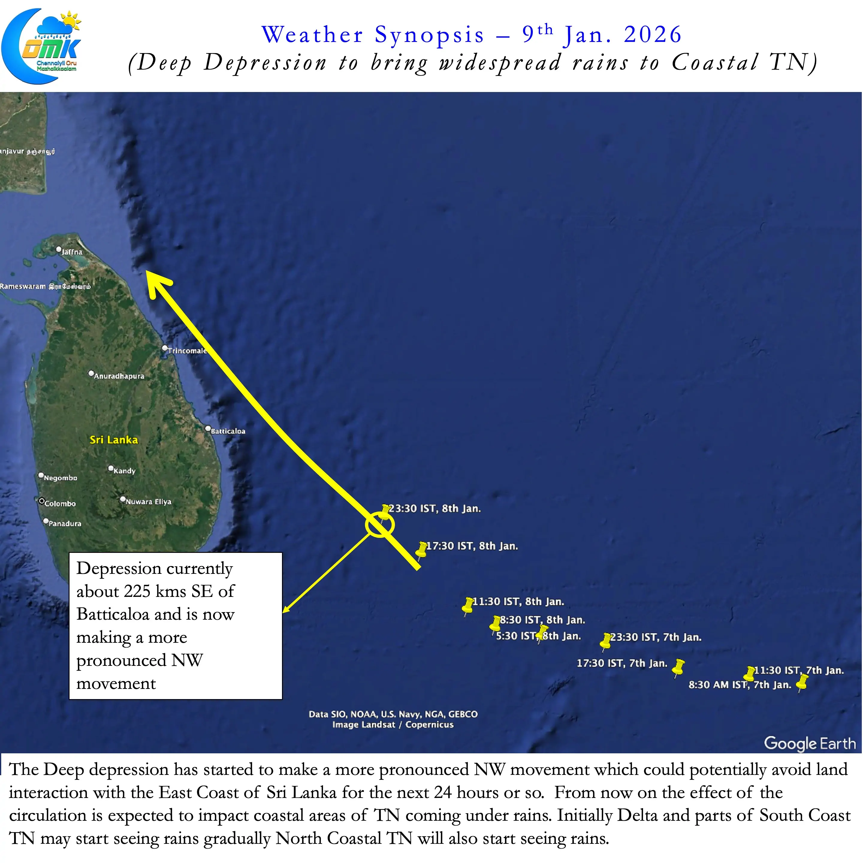
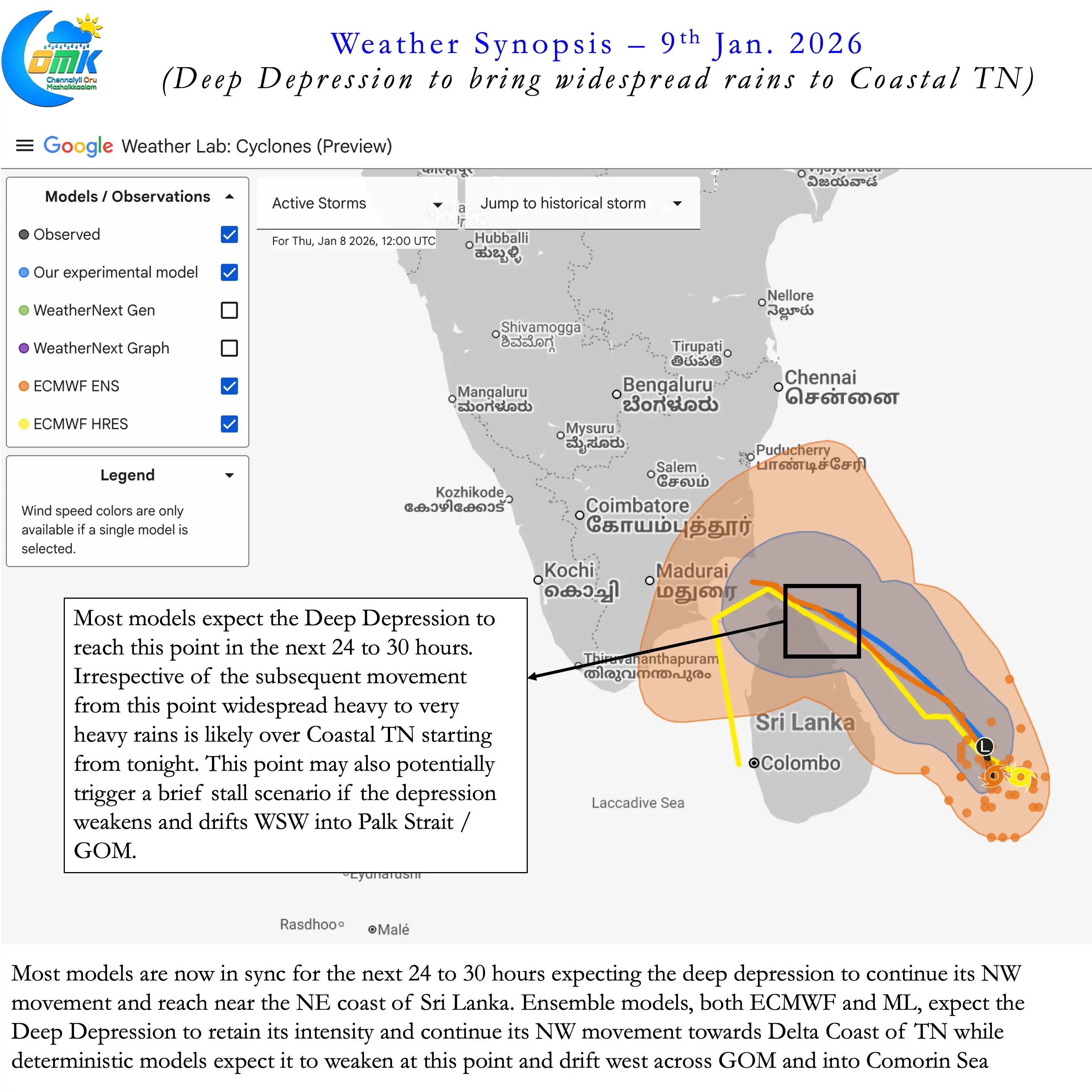
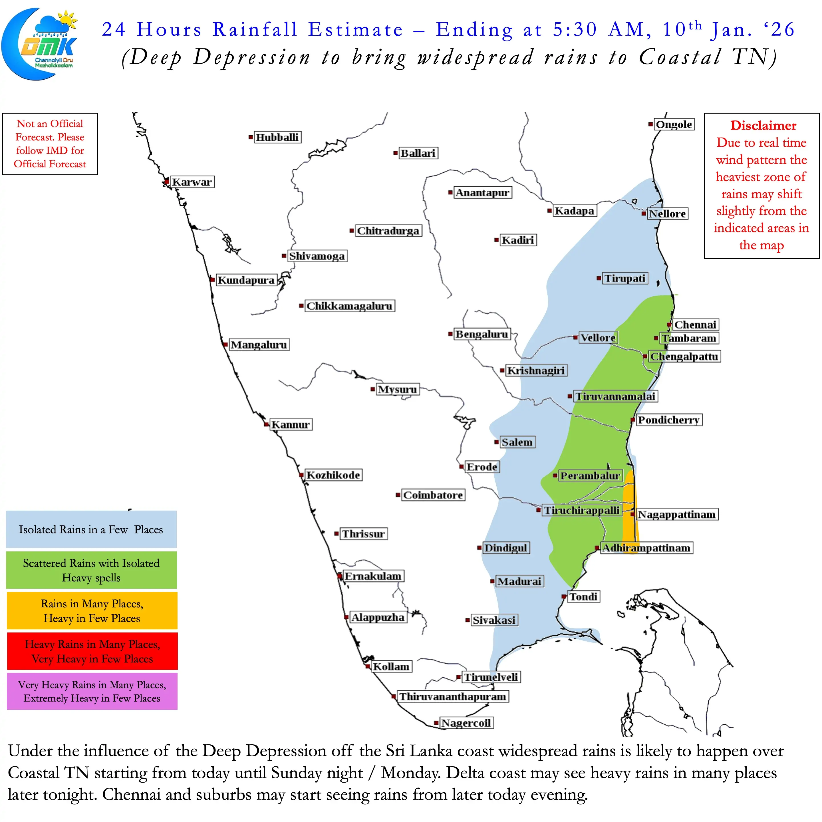
Most models are now in sync about the next 24 hours. The system is now expected to drift along the East of Sri Lanka coast in a NW movement. It is likely to reach close to NE coast of Sri Lanka sometime tomorrow morning. At this point there are two scenarios being estimated by weather models. Ensembles of ECMW and ML models estimate the Deep Depression to maintain intensity. Due to this it expects further NW movement towards Delta coast of TN. Subsequently it is likely to weaken and drift into Coastal TN as a weak disturbance.
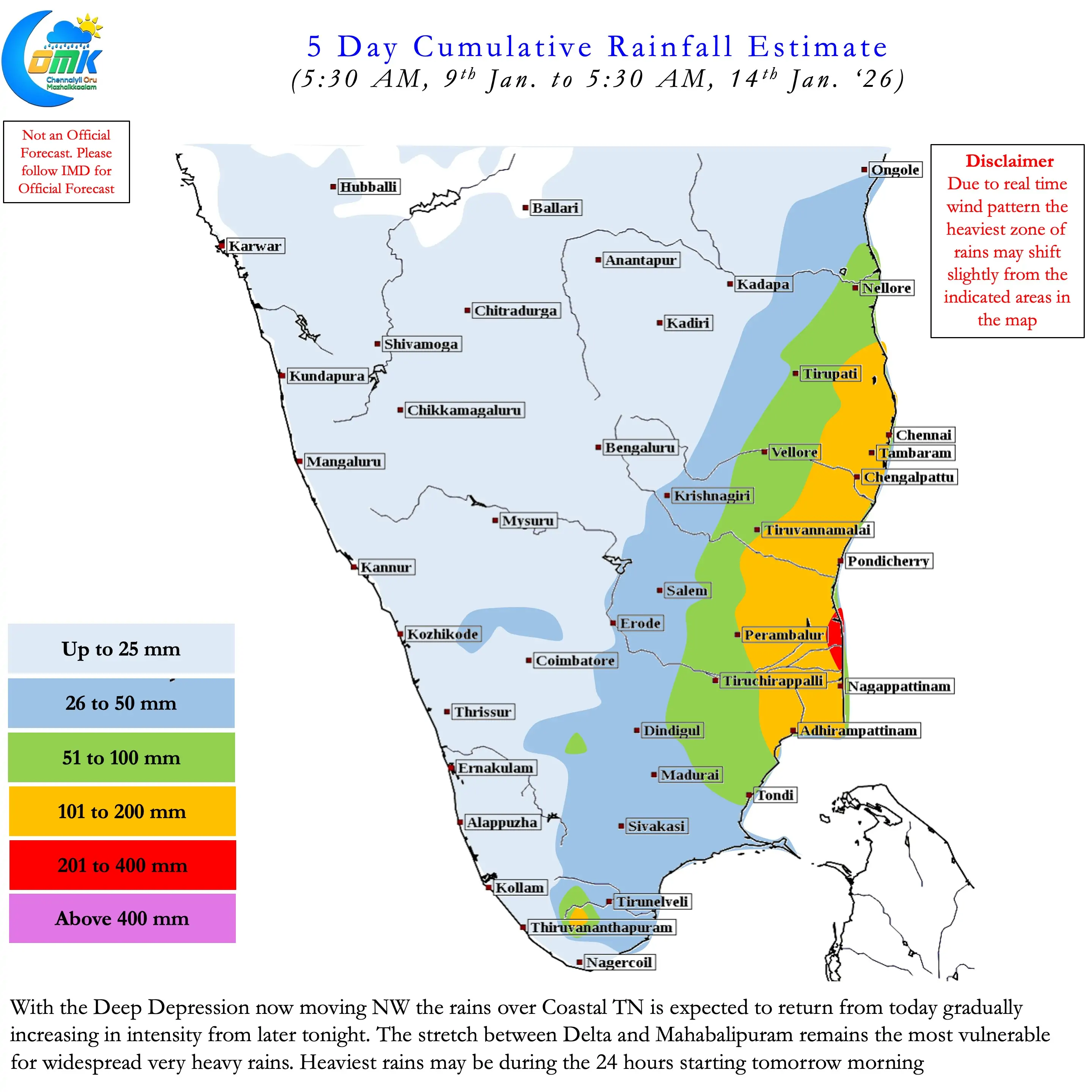
On the other hand deterministic models expect the system to weaken and drift WSW across Sri Lanka into Palk strait and GOM. This scenario may bring about more rains to South TN than initial expectations a couple of days back. Nevertheless both the scenarios are likely to bring widespread heavy rains to coastal TN. In particular the coastal stretch between Delta and Mahabalipuram remains vulnerable for very heavy rains at many places.
The intensification of the system to a Deep Depression has also potentially increased rainfall prospects for places like Chennai. Widespread heavy to very heavy rains may happen over Chennai and suburbs during the 24 hours staring tomorrow. There is a good chance for Very heavy rains over a few places as well considering the interaction with westerly trough. Additionally this interaction may also potentially lead to a brief stall near NE Sri Lanka coast. This brief stall may bring about very heavy to extremely heavy rains over isolated places between Chidambaram and Chennai.
Farmers across the coastal stretch between Pudukottai and Tiruvallur districts should take sufficient safeguard for their harvested grains. Rains are likely to continue until Monday morning before gradually fading away as the circulation weakens and drifts further West.