
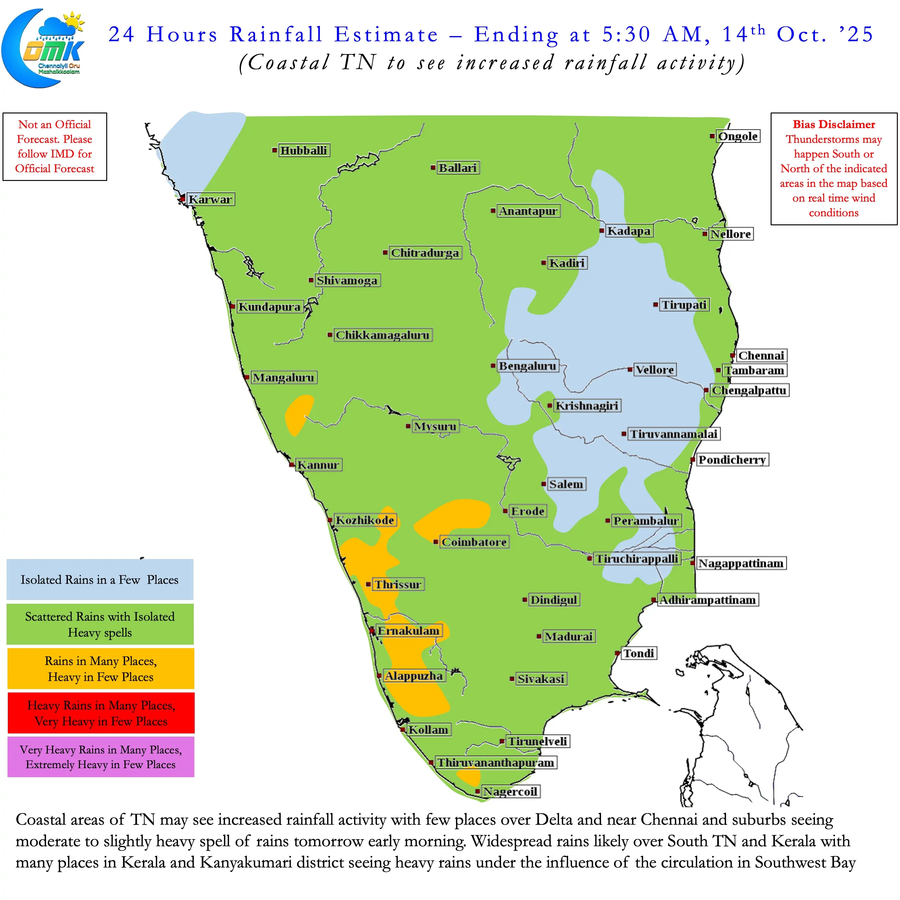
It is that time of the year not only one sees butterflies to the East of Chennai in the radar but also butterflies fly in the stomachs of weather bloggers. After nearly 5 months of looking West for rains it is not time to look East for rains. It is time for NEM 2025. The Chennai DWR Volume Velocity Processing Charts does confirm the arrival of Easterlies over North Coastal TN. The winds are not strong enough yet as seen through the DWR. But the stage is set for the onset of Northeast Monsoon in the next 24 to 48 hours. Chennai and suburbs received light to moderate rains at many places after midnight today.
he early morning rains from the sea is yet another confirmation NEM 2025 is not far away. Early morning rains along the Peninsular East coast is a classical feature of Northeast Monsoon season. IMD will announce the exact onset date based on prevailing conditions as seen by them. Until then we can enjoy the rains that move in from the sea.
It is common knowledge the rainfall episodes of Northeast Monsoon is closely linked to tropical disturbances. Depending on when, where and how tropical disturbances move Peninsular India sees rains. If a cyclone moves towards North bay it brings about a period of dry weather in Peninsular India. Similarly if a LPA is in Gulf of Mannar it brings widespread heavy rains over most of Tamil Nadu.
Tracking these tropical disturbances always come with a risk. The risk becomes higher when we look over a longer time frame. It is in this context it becomes essential to keep a more grounded approach while decoding the expected weather events. Deterministic model outputs give a fair indication in the 0 to 120 hours window. Ensembles give a fair indication of the 120 to 240 hours window. The availability of AI based weather model outputs has brought a different dimension. It has provided an alternate view to see through weather events during this 120 to 240 hours window.
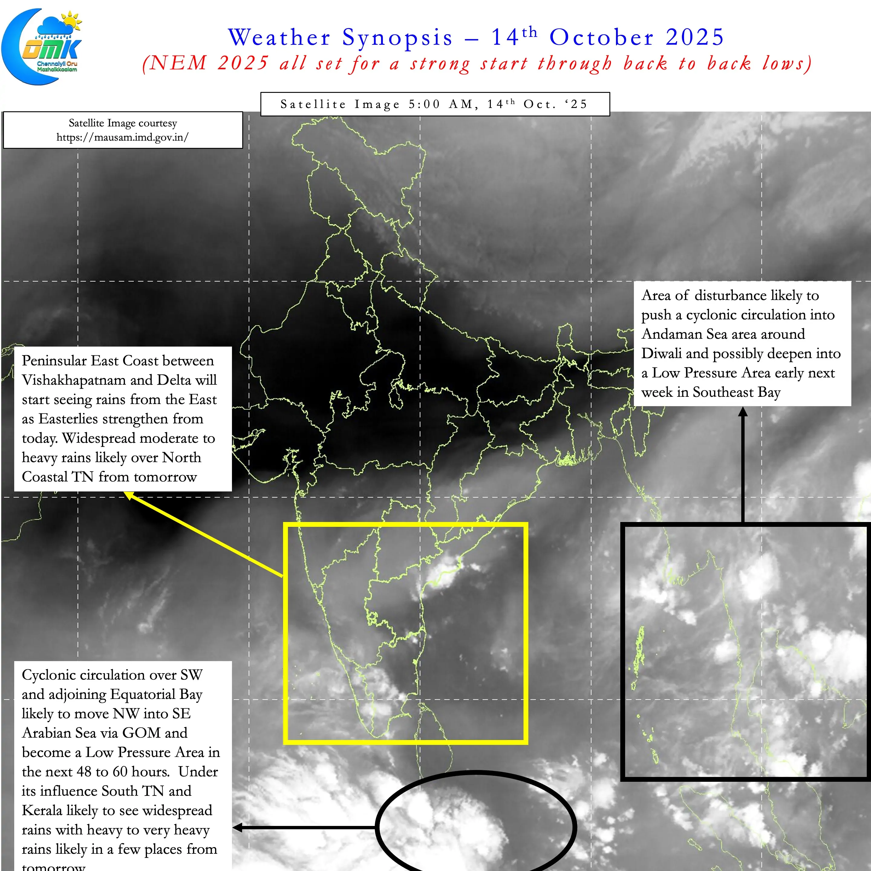
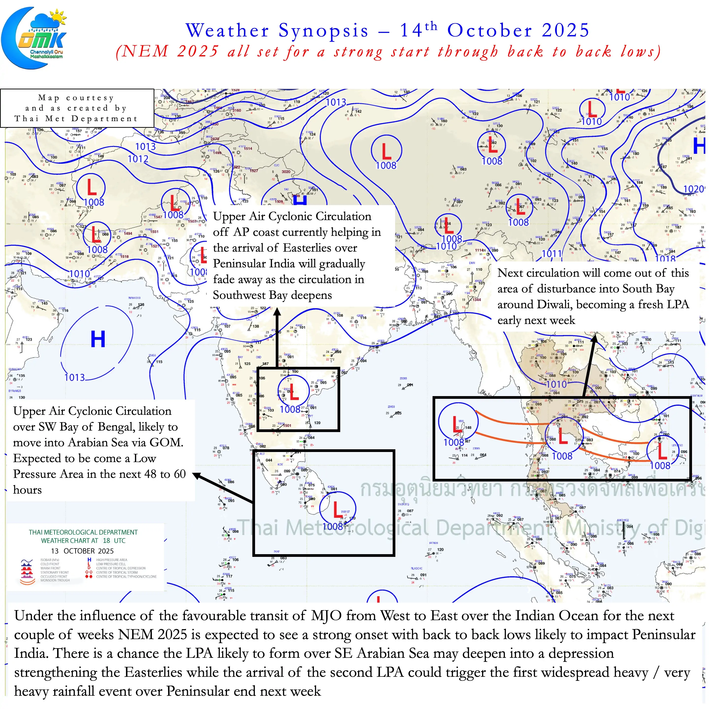
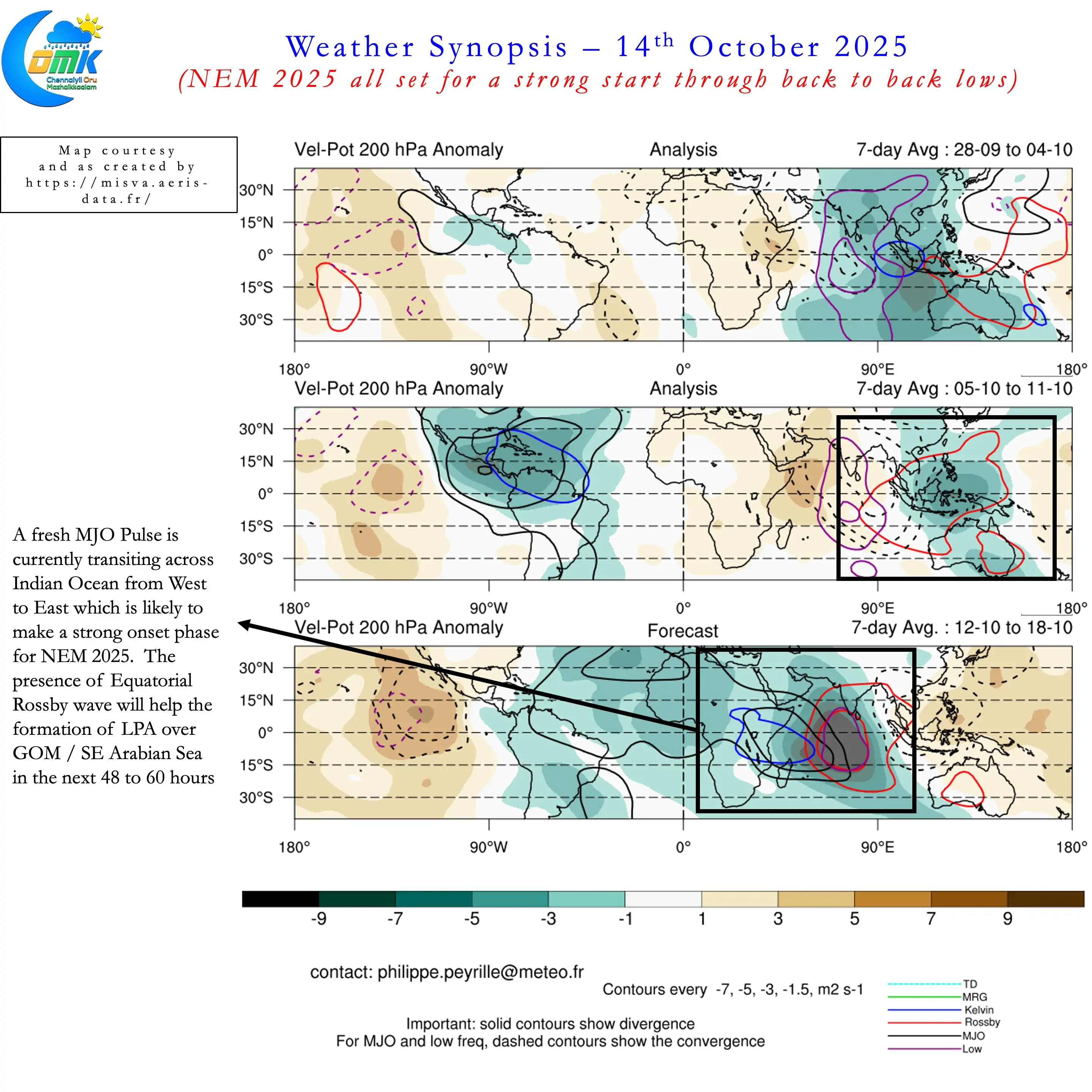
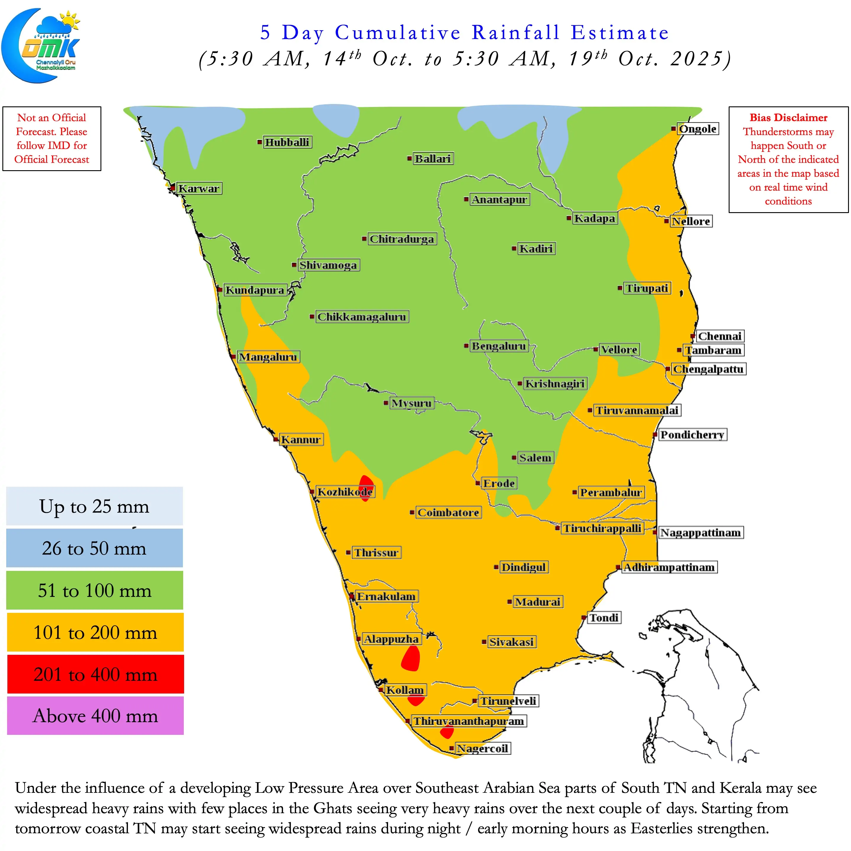
It is in this context we can see potentially Back to Back Lows bring a strong start to NEM 2025. The first LPA is likely to form over SE Arabian sea from the cyclonic circulation currently over SW Bay. This circulation is likely to move over GOM bringing about widespread rains over South TN and Kerala. There is a chance this LPA may deepen into a Deep Depression / Marginal cyclone. In which case it would strengthen the Easterlies along Peninsular India. This would mean the rainfall meter along Coastal TN will continue to tick until the 2nd LPA gets ready.
The 2nd LPA is likely to develop out of an area of disturbance currently seen over Indo China Peninsula. This is likely to move as a cyclonic circulation into Andaman Sea around Diwali. Subsequently it is likely to deepen into an LPA early next week. We will have to wait and see where it takes genesis based on which the path and impact area will vary. There is a very high chance for a WNW / NW movement towards Peninsular East Coast though.
With MJO now transiting West to East over Indian Ocean it is tailor made for a strong start to NEM 2025. This is likely to make the 2nd fortnight of October wet for Peninsular India. Most places in the region may see above average rains though two areas may stand out. South TN and Kerala during the first phase up to Diwali. North Coastal TN and South Coastal AP during the 2nd phase immediately after Diwali. In between Diwali may be wet as well over most places in the region. Individual places may see rainfall quantum vary depending on real time conditions.
To cut a long story short. NEM 2025 may opt for an early power play. A wet couple of weeks is ahead for most places in Coastal TN.