
It was a “Chennai Special” yesterday from the Thunderstorms as most of Tamil Nadu saw little rains while places within 50 – 100 kms of Chennai saw the bulk of rains as continuous rains lashed across the city from evening till well past midnight bringing much cheer to the citizens of the metropolis. It is a common discussion among weather bloggers when Chennai gets rains the rest of the place remain spectator, yesterday proved this once again.
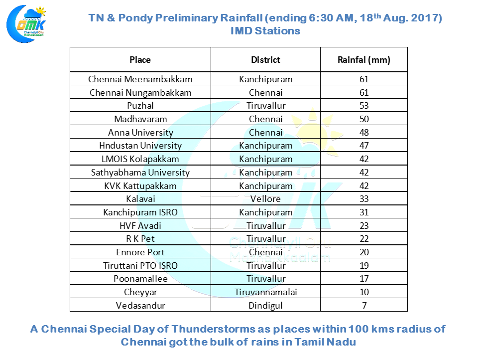
In what could be considered as the first fully widespread of rains for the city this season most of the IMD observatories in the city recorded 4 to 6 cms of rains as both Nungambakkam & Meenambakkam observatories recorded an identical 61 mm rains till 5:30 in the morning. In the past we have seen some parts of the city record intense rains while many others missed out which was not the case yesterday.
In the past more often than not Chennai possibly gets the last good spell of rains before the thunderstorm season takes a break from this part of the country and monsoon dynamics shifts back to rest of the country. Yesterdays could possibly turn out to be that defining spell that is likely to bring a shift in dynamics. With Bay of Bengal churning out the next disturbance in a day or two we are going to see the typical monsoon dynamics change once again and the rains are expected to ease over Tamil Nadu. While there is a slight chance of some afternoon / evening rains in the extreme North TN around Chennai overall the rains will start to fade away.
Under the influence of the Upper Air Cyclonic Circulation in the vicinity parts of Coastal AP & Telengana is likely to see rains at most places with a few places likely to see moderate to heavy rains today. Similarly we can see some bit of momentum build over the West Coast as well thanks to the moisture drag created by the circulation.
Powered by WPeMatico